Austin Lifestyle · June 2026
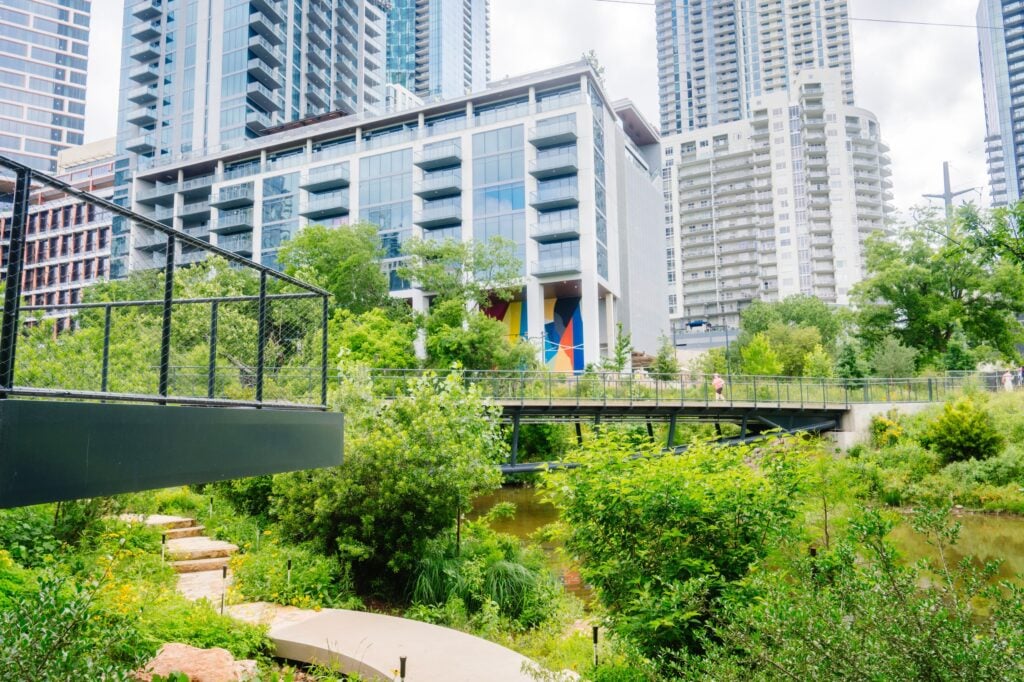
On June 6, 2026, Austin opened The Confluence — Phase II of the Waterloo Greenway — and in doing so, fundamentally changed the trail geography of its downtown. Thirteen acres of new parkland along Waller Creek, from 4th Street to Lady Bird Lake, are now open to the public. What was once a neglected flood corridor running through the heart of the city is now a continuous off-street trail connecting Austin's urban core to its beloved hike-and-bike network along the lake. It has been coming for years. It is worth understanding now that it is here.
Talk to The Davis Agency Search Austin Listings
13 acres New Downtown Parkland Along Waller Creek, 4th St to Lady Bird Lake | $85M+ Total Construction Cost City of Austin + Waterloo Greenway Conservancy | 200,000+ Native Plants 1,600+ trees, 200 native species restored | 11 blocks Connected Through Downtown Republic Square to Lady Bird Lake — full Greenway vision |
The Waterloo Greenway has been Austin's most consequential infrastructure project of the past decade, and most Austinites have watched it develop from a distance — seeing the construction fencing along Waller Creek, noting the detours on the hike-and-bike trail, reading the announcements about phased openings without quite tracking what the finished project would actually deliver. Now that The Confluence is open, the full picture is visible — and it is more significant than the construction fencing ever suggested.
What the Waterloo Greenway Actually Is
The Waterloo Greenway is a 35-acre linear park running through 11 city blocks of downtown Austin, following Waller Creek from Republic Square Park near the Convention Center south to Lady Bird Lake. The vision — developed over more than a decade of planning and collaboration between the City of Austin and the Waterloo Greenway Conservancy — was to transform what had been a neglected, flood-prone urban creek corridor into a continuous green spine through the heart of downtown.
Phase I was Waterloo Park, which opened in 2021 and includes the Moody Center's neighbor amphitheater, meadow areas, and the northern section of the creek trail. Phase II — The Confluence — extends that green corridor south from 4th Street all the way to Lady Bird Lake, adding 13 acres of new parkland and completing the connection between downtown's street grid and the Ann and Roy Butler Hike-and-Bike Trail that rings the lake.
What makes The Confluence specifically significant is the southern connection. The Hike-and-Bike Trail is one of Austin's most beloved public spaces — 10 miles of waterfront trail circling Lady Bird Lake, used daily by runners, cyclists, kayakers, and dog walkers from across the city. Before The Confluence, reaching the Hike-and-Bike Trail from the eastern downtown and Rainey Street neighborhoods required navigating surface streets and dealing with the at-grade intersections of Cesar Chavez and Red River. Now there is a continuous, off-street path from 4th Street to the lake — one of the most significant trail infrastructure improvements the city has made in years.
From Dumping Ground to Gem of the City
Waller Creek, before this project, was a symbol of Austin's unfinished urban ambitions — a flood-prone creek corridor that divided rather than connected, lined with concrete and largely inaccessible. At the grand opening ceremony, city and community leaders called The Confluence "a gem of the city" and acknowledged what it had previously been: a dumping ground and source of flooding. The transformation from urban liability to civic asset is one of the clearest expressions of what Austin is capable of when public and private investment are aligned around a shared vision.
What The Confluence Actually Includes
The scope of what opened on June 6 is more detailed than the trail-connection headlines suggest. Here is what The Confluence delivers across its 13 acres.
The boardwalk and trail connection. An 800-foot elevated boardwalk runs along Waller Creek, allowing trail users to travel continuously from Palm Park to the Rainey Street area and the Ann and Roy Butler Hike-and-Bike Trail without touching a single intersection. The boardwalk bypasses the grade-level crossings at Red River Street and Cesar Chavez Street entirely — the specific point in the trail network that has historically forced trail users onto surface streets in this corridor.
Three lattice bridges. Three new pedestrian bridges cross Waller Creek at different points along the corridor, providing new east-west connections for pedestrians and cyclists between the downtown grid east and west of the creek. These bridges are not purely utilitarian — the lattice design is architecturally considered in a way that signals the Greenway's ambition to be a genuine public space rather than just a utility corridor.
The Lagoon Overlook and Leaf Deck. A new gathering space adjacent to Lady Bird Lake, the Lagoon Overlook and Leaf Deck give visitors a specific destination at the southern end of the trail — a place to stop, sit, and look out over the lake rather than simply passing through. This kind of designed endpoint is what separates a trail corridor from a park, and it is what makes The Confluence a destination rather than just a path.
The Cypress Grove and Trailhead Plaza. At the northern end at 4th Street, the Cypress Grove and Trailhead Plaza establish a formal entry point to the Greenway from the downtown street grid — with native cypress trees, a defined plaza space, and the orientation infrastructure that makes a new park legible to first-time visitors.
The Lakeview Terrace and Explorers Garden. A shaded, family-friendly gathering area near the southern end that includes seating, shade structures, and interpretive plantings designed for children to explore. The family programming dimension of The Confluence is intentional — this is not an amenity designed exclusively for the fitness crowd.
The Biofiltration Pond. A critical piece of infrastructure that is easy to overlook in the lifestyle coverage: a biofiltration pond completed in October 2025 that is now fully operational, improving water quality in Waller Creek by filtering runoff before it reaches the creek and Lady Bird Lake. The pond removes trash and debris, reduces pollutants, and creates a more resilient creek ecosystem. This is the infrastructure work that makes the ecological restoration possible rather than merely decorative.
The Ecological Restoration: More Than Landscaping
The scale of ecological restoration in The Confluence is worth understanding because it distinguishes this project from standard urban park development. The 1,600 trees, 200,000 plants, and 200 native species planted across the 13 acres represent not just landscaping but a genuine attempt to rebuild the creek ecosystem that existed in this corridor before urbanization degraded it.
Before the project was even complete, nature was responding. Waterloo Greenway Conservancy's executive team noted at the grand opening that birds, turtles, fish, and — notably — a beaver had already established themselves in the new ecosystem before the public arrived. The fact that wildlife was "making its way back in" before the ribbon cutting is the most genuine possible validation of the restoration work.
The ecological and recreational dimensions are not separate — they are the same project. The habitat that supports turtles and a beaver is also the habitat that makes walking the boardwalk feel like an encounter with nature rather than a walk through a landscaped median. That quality of experience is what elevates The Confluence above a standard urban trail improvement and into something that people will return to for the same reason they return to Barton Springs or the Greenbelt.
What It Connects: Understanding The Confluence in the Broader Trail Network
To understand why The Confluence matters for Austin's overall trail infrastructure, it helps to trace the connected path that is now possible from the northern end at 4th Street through to the broader system.
From the Trailhead Plaza at 4th Street, the trail connects north to the Lance Armstrong Bikeway — the protected bike lane along Cesar Chavez — and to Palm Park in the heart of the East 6th Street corridor. Heading south on the boardwalk, the trail passes through the new park sections and emerges at the Ann and Roy Butler Hike-and-Bike Trail at Lady Bird Lake. From there, the 10-mile lake loop connects west to Zilker Park, Barton Springs Pool, and the Barton Creek Greenbelt access points — or east toward the Longhorn Dam and the eastern portions of the hike-and-bike system.
The practical meaning: a resident of the Rainey Street district, East 6th Street, or the downtown area can now reach Zilker Park and Barton Springs Pool on an almost entirely off-street route without touching a car. The missing link in downtown Austin's trail connectivity — the awkward, incomplete section between 4th Street and the lake — no longer exists.
The trail access premium, now extended into downtown
The Davis Agency has written extensively about what Greenbelt proximity does to property values in Barton Hills and Zilker — and the mechanism is the same here: when genuine, accessible outdoor amenity moves within walking distance of a residential address, that proximity has financial value. Neighborhoods that can now reach Lady Bird Lake via The Confluence without navigating surface-level traffic intersections just got meaningfully closer to Austin's most beloved outdoor resource.
What This Means for Austin's Neighborhoods
The Confluence most directly benefits the neighborhoods that sit within walking distance of Waller Creek's newly accessible corridor. The Rainey Street District — the cluster of bars, restaurants, and residential buildings immediately east of the creek's southern section — gains direct, off-street trail access to Lady Bird Lake that previously required navigating Cesar Chavez traffic. East downtown residential buildings, the new mixed-use developments along Red River, and the residential streets of East 6th Street gain meaningful pedestrian and cycling connections to the broader park and trail network.
For Austin's broader geography, The Confluence completes the downtown segment of a trail system that already extends south through Zilker Park to the Barton Creek Greenbelt and north through various trail connections toward the Domain and Mueller. The 35-acre Waterloo Greenway, once complete across all phases, will form one of the most significant continuous green corridors in any American city of Austin's size — running from the northern Convention Center area to Lady Bird Lake through the heart of downtown.
The neighborhoods that have long benefited from proximity to the southern portions of this network — Barton Hills, Zilker, Bouldin Creek, and Travis Heights — now exist in a broader trail ecosystem that extends further north and east than it did before June 6. Austin is not a city that takes its park and trail infrastructure for granted, and The Confluence is evidence that the investment in that infrastructure continues.
What's Next for the Waterloo Greenway
The opening of The Confluence represents Phase II of what is ultimately a larger vision. The full Waterloo Greenway runs 11 blocks from Republic Square near the Convention Center to Lady Bird Lake — and while Phase I (Waterloo Park) and Phase II (The Confluence) are now open, the complete integration of all planned phases and amenities continues. The Creek Show, one of Austin's beloved annual light and art installations, is already confirmed to move to The Confluence for 2026, returning "bigger and brighter" in the new space. The park was designed with programming in mind, and the events calendar for this new green space is expected to build over the coming years as Austinites discover and adopt it.
Why Austin keeps doing this
The Barton Springs Pool restoration. The Lady Bird Lake hike-and-bike trail. The Barton Creek Greenbelt's managed access. Waterloo Park and now The Confluence. Austin has a track record of committing public and private investment to the kinds of outdoor infrastructure that shape how people experience the city — not as destination amenities but as the daily backdrop of life here. The Confluence continues that tradition. For people who are considering Austin as a place to live, that track record is as relevant to the decision as any neighborhood guide or school district ranking.
Frequently Asked Questions
Is The Confluence free and open to the public?
Yes — The Confluence is a public park, free and open to all. The grand opening on June 6 was free admission, and the park itself has no entry fee. As with all City of Austin parks, access is available during park hours. The trail connection to the Ann and Roy Butler Hike-and-Bike Trail means that pedestrians and cyclists can move continuously between The Confluence and the broader Lady Bird Lake trail network without any access fee.
Is it accessible for cyclists as well as pedestrians?
Yes. The continuous off-street trail through The Confluence is designed for both pedestrians and cyclists, connecting to the Lance Armstrong Bikeway at the northern end and the Ann and Roy Butler Hike-and-Bike Trail at the southern end. The boardwalk and trail connections are specifically designed to eliminate the at-grade intersections at Red River Street and Cesar Chavez Street that previously interrupted cycling routes through this corridor.
What neighborhoods benefit most from The Confluence's opening?
The Rainey Street District, East 6th Street, and the broader East Downtown area benefit most directly — gaining off-street trail access to Lady Bird Lake that was previously impossible without navigating surface-level traffic. Residents and visitors throughout downtown Austin benefit from the new east-west pedestrian connections over Waller Creek provided by the three new bridges. The wider Austin trail community benefits from the completed connection between the downtown trail network and the Lady Bird Lake hike-and-bike system.
How does The Confluence connect to the rest of the Waterloo Greenway?
Phase I (Waterloo Park) runs from approximately 10th Street to 4th Street in the northern section of the Greenway corridor. Phase II (The Confluence) picks up at 4th Street and runs south to Lady Bird Lake. Together the two phases cover the majority of the Waterloo Greenway's planned 35 acres. Waterloo Park's amphitheater, meadow spaces, and northern trail connections are already operational — The Confluence completes the southern segment and the critical connection to Lady Bird Lake.
Related Reading from The Davis Agency
→ Living on the Greenbelt: What Trail Access Actually Does to 78704 Home Values
→ The Barton Springs Effect: How Austin's Most Iconic Amenity Drives Property Values
→ Inside Zilker: A Neighborhood Character Guide for Luxury Buyers
→ South Congress as a Real Estate Asset: How SoCo Proximity Drives Property Values in 78704
Searching for a Home Near Austin's Trail Network?
Austin's park and trail infrastructure is one of the most compelling arguments for where you choose to live in this city. The Davis Agency tracks trail-adjacent inventory across 78704 and the broader Austin luxury market — including off-market opportunities that never reach public listings.
Search Current Listings Call (512) 608-8811
Or email [email protected]. Derrik responds personally.
Derrik Davis · Broker/Owner, The Davis Agency · CLHMS Certified · TREC License #558841 · Serving Austin's luxury market since 2006.